Franciscan Eastern Belt
Submitted abstract and Map
GSA abstract
Grindstone Creek summary
agu POSTER
Preliminary abstract as of February 2023
Textural alteration, faulting and accretion within the Yolla Bolly area, Eastern Belt of the Franciscan Complex in Northern California
By Thomas C. MacKinnon, 20 Tara Road, Orinda, CA 94563
Abstract
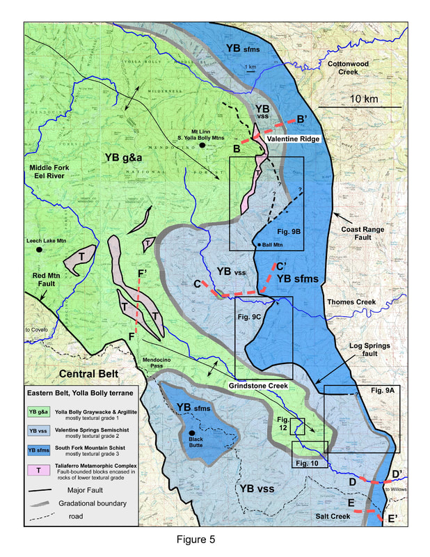
Within the Franciscan Complex of Northern California, one of the most widely studied areas is the Yolla Bolly area of the Eastern Belt. The area is approximately 40 km wide, is bounded to the east by the Coast Range fault and to the west by the Central Belt and represents ~25 my of the early accretionary history of the Franciscan. A defining feature of the area is textural. A belt of schist (South Fork Mountain Schist) lies adjacent the Coast Range fault followed to the west by semischists (Valentine Spring Formation); these units comprise what is known as the Pickett Peak terrane. Further west is a broad area of non-schistose rocks known as the Yolla Bolly terrane. The three units are generally believed to be separated by major regional faults (Log Spring and Sulphur Creek); however, the presence of these faults is controversial as some workers have argued that the contacts are gradational. To address this issue, the supposed faulted contacts were examined in multiple locations spanning most of their mapped extent. Samples were taken for thin sectioning for more accurate determination of textural grade. The data show that the contacts (i.e. the transition from schist to semischist to non-schistose rocks) are mainly gradational making the concept of two terranes untenable. It is further shown that textural zone boundaries cross-cut bedding; this means that the South Fork Mountain Schist and Valentine Spring Formation are textural facies, not rock-stratigraphic units and that lithification still continued after accretion of individual slices. Suggestions for a revised terminology are given. The origin of schistosity is not clear but may be related to an increase in fluid flux and fluid pressure along the original accretionary surface. A limited portion of the previously mapped Log Spring and Sulphur Creek faults are present in the central part of the study area. These faults along with those bounding the Taliaferro Metamorphic Complex and one other previously recognized show differences in temperature, pressure and textural grade across the fault traces and their origin must be post-accretionary; a normal fault origin is considered based on regional structural relations. Though major breaks in accretion seem likely over the estimated ~25 my history of the Yolla Bolly terrane; no such surfaces have yet been clearly recognized.
GSA Abstract, Cordilleran section, 2016, Ontario, CA
Are the contacts between the South Fork Mountain Schist, Valentine Spring, and Yolla Bolly units transitional or faulted in the Eastern Belt of the Franciscan Complex of California?
In the Eastern belt of the Franciscan, an inverse metamorphic gradient is defined by three units adjacent and west of the Coast Range fault: the South Fork Mountain Schist (SFMS), Valentine Spring (VS, largely semi-schistose) and Yolla Bolly (YB, non-schistose). The nature of the contacts between these units has been the subject of controversy for many years. Some workers believe the contacts are faults (Log Springs and Sulfur Creek) defined by abrupt breaks in metamorphic and textural grade. Other workers believe the contacts are transitional as they have been unable to document the abrupt breaks described by fault advocates. Recent workers appear to have accepted the fault interpretation, probably because the contacts have been enshrined as faults on the most recent geologic maps. However the issue remains unresolved in large part because, with one debatable exception, the fault traces have not been seen in outcrop despite their regional extent.
The mapped trace of the Sulfur Creek “fault?” was examined in Grindstone Creek, near Willows, CA. The “fault?” separates non-schistose YB rocks from VS semischists (~textural grade 1 to 2). The textural zone boundary can be seen to cut across steeply dipping beds at a low angle; it can be walked across along a trail, in the main stream, and up two side creeks. No sharp break in textural grade or lithology was observed. Instead, a gradual transition from non-schistose to semischistose rocks is clearly seen over an ~100 meter interval. The trace of the Log Springs “fault?” is well exposed in Grindstone and Salt Creeks; it roughly defines the boundary between semischists (VS) and schists (SFMS) (~ textural zone 2 to 3). The change in textural grade appears to be transitional over several hundred meters. The transition appears to be related in part to a change in sandstone character, from thin-bedded in the SFMS to thicker bedded in the VS unit. Thin section studies confirm all textural changes described above. In summary, the boundaries between the YB, VS and SFMS units are transitional in the areas studied and are likely to be so throughout the Eastern Belt.
| gsa_talk.pdf | |
| File Size: | 6045 kb |
| File Type: | |
Grindstone Creek summary
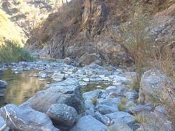
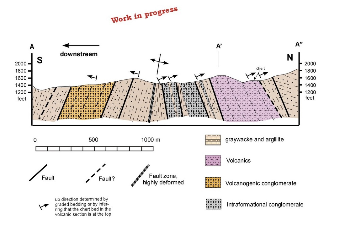
Here is a summary of some of my work in Grindstone Creek. The outcrops are exceptional as you will see in the photos in the file attached below. Most of the rocks are graywackes and argillites. Also present are some chert-pebble conglomerates and two volcanic sequences. One of the volcanic sequences is typical of the Franciscan. The other is a silicic volcaniclastic sequence (orange in the cross-section below); as far as I know the volcaniclastic section is unique; in other words, no other similar rocks have been described elsewhere in the Franciscan.
Here is a summary of some of my work in Grindstone Creek. The outcrops are exceptional as you will see in the photos in the file attached below. Most of the rocks are graywackes and argillites. Also present are some chert-pebble conglomerates and two volcanic sequences. One of the volcanic sequences is typical of the Franciscan. The other is a silicic volcaniclastic sequence (orange in the cross-section below); as far as I know the volcaniclastic section is unique; in other words, no other similar rocks have been described elsewhere in the Franciscan.
| franciscan_upstream_grindstone_summary.pdf | |
| File Size: | 9497 kb |
| File Type: | |
Here is the abstract and poster I presented at the AGU in December 2015

AGU Abstract, December 2015, San Francisco
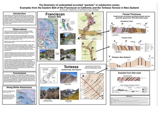
The geometry of underplated accreted “packets” in subduction zones; examples from the Eastern Belt of the Franciscan in California and the Torlesse Terrane in New Zealand
By Thomas C. MacKinnon, 20 Tara Road, Orinda, CA 94563
Accretion is a complex process, the details of which cannot be resolved seismically. Well-exposed ancient examples offer a better opportunity. This study focuses on two areas with nearly 100% exposure: glaciated exposures of the Torlesse near Arthur’s Pass, New Zealand and stream-cut exposures of the Franciscan Eastern Belt in Grindstone and Thomes Creeks, California. Rocks are mainly turbidites of prehnite-pumpellyite to lower blueschist grade, described as “broken formation” with no melange or exotic blocks present.
The dominant structural features are steeply dipping beds cut by thrust faults oriented at a modest angle to bedding. Fault spacing ranges from ~100 to 600 meters with the angle between bedding and faults usually ranging from 0° to 35°. Between faults, bedding continuity, though locally disrupted, is generally well-preserved. Deformation associated with the faults is variable. In some cases, fault contacts are sharp and show little deformation of adjacent beds. In other cases, small folds, boudinage, and intense fracturing and veining define fault zones. Intensity of deformation varies along the fault plane and is commonly more intense on one side than the other. Of note are two additional faults present in the Thomes Creek area; they are out-of-sequence thrusts (OOST’s) that cross-cut the other faults at high angles and are associated with a greater degree of deformation. Aside from these OOST’s, deformation associated with the faults is roughly an order of magnitude less than that described in the literature for “megathrusts.”
The faults described above (excluding the OOST’s) represent primary surfaces along which “packets” of relatively intact rocks were accreted. This study and others show that these fault-bounded packets can be traced along strike for a few km to at least 10 km or more where not cut by OOST’s or younger faults. The faults appear to form after a period of diffuse, largely extensional shear in semi-consolidated sediments; as rigidity increases, shear becomes localized along fault surfaces. It is inferred that this process is driven by a plate boundary megathrust located some distance structurally below the accreted packets. Such megathrusts may be rarely preserved as they have not been observed in the areas studied.

| agu_poster.jpg | |
| File Size: | 1075 kb |
| File Type: | jpg |
| agu_abstract.docx | |
| File Size: | 15 kb |
| File Type: | docx |


